Ooststellingwerf
| Ooststellingwerf | ||||
 Armoiries. |
 Drapeau. |
|||
 Crédit image: H.P.Burger licence CC BY 3.0 🛈 Écluse du canal traversant Appelscha | ||||
| Administration | ||||
|---|---|---|---|---|
| Pays | ||||
| Province | Frise | |||
| Code postal | 8421-8435 | |||
| Indicatif téléphonique international | +(31) | |||
| Démographie | ||||
| Population | 26 182 hab. | |||
| Densité | 116 hab./km2 | |||
| Géographie | ||||
| Coordonnées | 52° 59′ 00″ nord, 6° 18′ 00″ est | |||
| Superficie | 22 664 ha = 226,64 km2 | |||
| Localisation | ||||
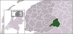
 | ||||
| Géolocalisation sur la carte : Pays-Bas
Géolocalisation sur la carte : Pays-Bas
Géolocalisation sur la carte : Frise
| ||||
| Liens | ||||
| Site web | www.ooststellingwerf.nl | |||
Ooststellingwerf est une commune néerlandaise de la Frise.
Population
Évolution de la population
3 990 ()[1]
4 937 ()[1]
6 452 ()[1]
8 354 ()[1]
9 045 ()[1]
9 190 ()[1]
9 315 ()[1]
9 582 ()[1]
10 414 ()[1]
13 059 ()[1]
14 558 ()[1]
16 911 ()[1]
18 913 ()[1]
20 087 ()[1]
23 957 ()[1]
24 934 ()[1]
26 238 ()[1]
26 004 ()[1]
25 573 ()
25 540 ()[2]
25 531 ()
25 459 ()[2]
25 497 ()[2]
25 469 ()[3]
25 464 ()[4]
Notes et références
- « https://easy.dans.knaw.nl/ui/datasets/id/easy-dataset:76773/tab/2 »
- « https://opendata.cbs.nl/statline/#/CBS/nl/dataset/70072NED/table?dl=2096B »
- ↑ StatLine (base de données).
- ↑ Bureau central de la statistique (institut officiel de statistique).
Liens externes
- (nl) Site officiel
- Ressource relative à la musique :
- (nl) Site officiel


