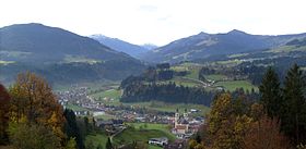
Hopfgarten im Brixental
| Hopfgarten im Brixental | |
 Héraldique |
|
 Crédit image:
licence CC BY-SA 3.0 🛈 | |
| Administration | |
|---|---|
| Pays | |
| Land | |
| District (Bezirk) |
Kitzbühel |
| Maire | Paul Sieberer (ÖVP) |
| Code postal | A-6361 |
| Immatriculation | KB |
| Indicatif | +43 5335 |
| Code Commune | 7 04 06 |
| Démographie | |
| Population | 5 599 hab. (2015) |
| Densité | 34 hab./km2 |
| Géographie | |
| Coordonnées | 47° 27′ 00″ nord, 12° 10′ 00″ est |
| Altitude | 622 m |
| Superficie | 16 655 ha = 166,55 km2 |
| Localisation | |
| Liens | |
| Site web | http://www.hopfgarten.tirol.gv.at |
Hopfgarten im Brixental est une commune autrichienne du district de Kitzbühel dans le Tyrol.

Crédit image:
licence CC BY-SA 4.0 🛈


