Buckland (Massachusetts)
| Buckland | ||||
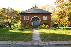
 Crédit image: licence CC BY 3.0 🛈 Bibliothèque publique de Buckland | ||||
| Administration | ||||
|---|---|---|---|---|
| Pays | États-Unis | |||
| État | ||||
| Comté | Comté de Franklin | |||
| Type de localité | Town | |||
| Code ZIP | 01338 | |||
| Code FIPS | 25-09595 | |||
| GNIS | 0618159 | |||
| Démographie | ||||
| Population | 1 902 hab. (2010) | |||
| Densité | 37 hab./km2 | |||
| Géographie | ||||
| Coordonnées | 42° 35′ 32″ nord, 72° 47′ 32″ ouest | |||
| Altitude | 210 m |
|||
| Superficie | 5 150 ha = 51,5 km2 | |||
| · dont terre | 50,9 km2 (98,83 %) | |||
| · dont eau | 0,6 km2 (1,17 %) | |||
| Fuseau horaire | EST (UTC-5) | |||
| Divers | ||||
| Fondation | 1779 | |||
| Municipalité depuis | 1779 | |||
| Localisation | ||||
 Crédit image: licence CC BY-SA 3.0 🛈 Carte du comté de Comté de Franklin. | ||||
| Géolocalisation sur la carte : États-Unis
Géolocalisation sur la carte : États-Unis
Géolocalisation sur la carte : Massachusetts
| ||||
| Liens | ||||
| Site web | http://www.town.buckland.ma.us | |||
Buckland est une municipalité du Comté de franklin au Massachusetts, fondée en 1779.
Sa population était de 1 902 habitants en 2010.
Localisation

Crédit image:
licence CC BY-SA 3.0 🛈


