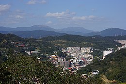
Anle
Anle

Crédit image:
lienyuan lee
licence CC BY 3.0 🛈
| Pays | |
|---|---|
| Province | |
| Ville provinciale | |
| Superficie |
18,03 km2 |
| Altitude |
95 m |
| Coordonnées |
25° 09′ N, 121° 42′ E |

Crédit image:
Original uploader was Essolo at zh.wikipedia
licence CC BY-SA 3.0 🛈
| Population |
80 115 hab. () |
|---|---|
| Densité |
4 443,4 hab./km2 () |
| Statut |
|---|
| Code postal |
204 |
|---|---|
| Site web |
(zh-Hant) www.klal.klcg.gov.tw |

Crédit image:
lienyuan lee
licence CC BY 3.0 🛈
Anle District (Chinois traditionnel: 安樂區 ; pinyin: Ānlè Qū) est un district de la municipalité de Keelung, à Taïwan.
Géographie
- Superficie : 18,025 km²
- Population : 82 338 habitants () [1]
Divisions Administratives
Le district d'Anle se subdivise en 14 villages:
- Anguo
- Baoding
- Daitiansfu
- Dawulun
- Gangkou
- Guanyin
- Maijin
- Qingrenhu
- Siding
- Sincheng
- Sinhuei
- Sinlun
- Wuling
- Yinggeshi [2]
Attractions touristiques
- Port de pêche d'Au-de
- Fort Dawulun
- Lovers Lake
- Temple Shi-fang-da-jyue
- Réservoir de Shin-shang
Personnalité liée au district
- Lu Shiow-yen, maire de Taichung
Voir aussi
Références
- ↑ (en) « Keelung City Anle District Office » [archive du ], Klal.gov.tw (consulté le )
- ↑ (en) « Anle Land Office, Keelung City - Introduction to the District » [archive du ], Anleh-land.gov.tw (consulté le )


